 The Glen Innes to Tamaki Drive Shared Path (Te Ara Ki Uta Ki Tai – the path of land and sea) aims to connect walkers and cyclists in Auckland’s eastern suburbs with the city centre, with links to public transport along the way.
Constructed mostly in concrete, the route is about 7 km long and 4 m wide and incorporates timber boardwalks for short water crossings. Once finished, it will close a gap in Auckland’s cycle network and connect with cycle routes to Point England and the shared path along Tamaki Drive.
Begun in 2015, the path is being built in 4 sections and is scheduled for completion in 2018. Section 1 (Mereton Road to St Johns Road) is open, and sections 2 (St Johns Road – Orakei Basin) and 3 (Orakei Basin Boardwalk) are well advanced.
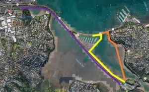
The route for Section 4 (Orakei Basin – Tamaki Drive) remains to be finalised. Several alternatives – each coloured differently in the accompanying illustrations – are among those currently being considered by Auckland Transport.
In the view of your Committee, the purple route is the best option: across Hobson Bay along the south side of the railway track to the pedestrian flyover bridge at Point Resolution, and further along Judges Bay towards the hill around Fred Hollows Lookout. Like the Orakei Local Board, your Committee proposes to advocate this alternative.
